
Profile of a
Sun-Earth
Observatory: ISTP
 
|

|

|

|
Spacecraft and significant computer and radar facilities are
provided
by:
Max Planck
Institute,
NOAA,
LANL, and the
Air Force.
Canadian Space Agency,
British Antarctic
Survey,
U.S. National Science
Foundation, and
Johns Hopkins
Applied Physics
Laboratory.
Where and
How?
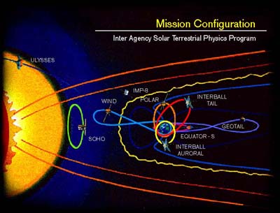
The spacecraft of ISTP are placed in orbits that allow
physicists to observe the key regions of Earth's space, or
"geospace."
Those
regions include the Sun's surface and atmosphere, the solar wind,
Earth's
magnetosphere, from the bow shock to the auroral regions to the
magnetic
tail.
Orbiting as far as one million miles from Earth and as close as a
few
hundred,
the spacecraft of ISTP make coordinated, simultaneous observations
of
the Sun
and geospace over extended periods of time.

With such observations, scientists are increasing our knowledge
of:
- The structure and dynamics of the Sun;
- The origin of the solar wind;
- The composition and character of the solar wind;
- The flow of energy between Sun and Earth; and
- The cause-effect relationship between events on the Sun and
their
impact on Earth.
When?
ISTP was conceived in the 1970s, planned in the 1980s, and
launched
in
the 1990s. The first spacecraft, Geotail, was launched in 1992,
and the
most
recent, Polar, went up in 1996. Each of the missions of ISTP is
scheduled to
continue through 1998, and scientists and engineers are now making
plans
to
extend their mission through the next solar maximum in
2000-2002.
Comments, Questions, Suggestions Webmaster
Author: Mike Carlowicz
Official NASA Contact: ISTP-Project
| NASA Home | Goddard Space Flight Center
Home |


