1. For good oval viewing, the equatorial edge of the Holzworth and Meng model was used for the Auroral Oval (GRL Sept 75, vol.2,no.9,pg. 377) with the Qindex set to 12. The earth horizon angle must be less than 10 degrees (i.e. the VIS Earth Camera half field of view), and the bottom the oval must be at least 25 degrees away from the horizon (ie. be able to detect about 1/2 the oval).
2. For the magnetopause boundary layer, Shue et al. JGR, 102, 9497, 1997 was used for the model magnetopause, with bz =0. ,p=3 nPa, which gives a standoff distance of 8.6 RE. The magnetopause boundary layer was defined as all points that are within 1.0 RE of the model surface or exterior of model surface.
3. The night side plasmasheet was defined as all points, with X_GSM < 0., radius > 7. RE and the distance to the neutral sheet of less than 2 RE. The neutral sheet model is from Tsyganenko (JGR 100, 5599, 1995).
4. The auroral acceleration region was defined as that the satellite must be on auroral field lines as defined by the region identifier at the satellite situation center at a radius of less than 5 RE.
The platform instruments require 1 hour of science mode 1 operations each orbit for acquiring health and safety data on their instruments.
Prime auroral imaging occurs from June 1 - January 31 and during this time the science mode default would be acquisition of images for the ~4 hours near apogee (auroral viewing) and the ~0.5 hour near perigee (auroral viewing and Jupiter viewing). Science mode 2 could be done in the remaining ~14 hours of the orbit.
Between February 1 and May 31, apogee is swinging across the dayside from 1500 LT to 0700 LT. During this time, the auroral viewing is diminished, but the great views of the dayside present the opportunities to measure the O/N2 composition changes. For these measurements, imaging observations lasting at least 1 hour per orbit straddling the equator are required. For this study, it is important to have a record of the O/N2 composition on each orbit. During the February 1 to May 31 season, the VIS team would support the science mode 2 operations for 1 in 4 orbits providing that they continue to acquire the 1 hour of imaging straddling the equator. This hour of dayside imaging straddling the equator would also suffice for the health and safety checks of the VIS.
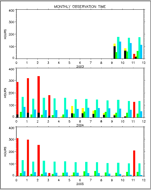
The bars on the plot are color coded as follows for each month.
1. red -magnetopause boundary layer
2. yellow - night-side plasmasheet
3. lime green - auroral acceleration region
4. turquoise - imaging
5. blue - auroral imaging
6. black - intersection of items 1 to 3 with good imaging of the auroral
oval
For example a red bar that is blacken at the bottom indicates the fraction of the time were good oval imaging is in conflict with science mode 2 operation during magnetopause boundary layer times for that month.